After hearing all the complaints in the Roosevelt Collection thread, I thought I would draft a plan myself for something MUCH better, that integrates parkland, the existing streetgrid, and transit. So here's my plan, rendered from Google Maps screencaps and composited in Photoshop.
Here's the idea - since there are several South Loop residents here, and because the forumers here obviously care about urbanism. Basically, I'm soliciting comments and suggestions from you guys to improve my plan. As it goes along, I will gradually move to 3dsMax to give rough-draft renderings for the new neighborhood. Then, for the inevitable, eventual public hearings on the development of this parcel, we as CBP can hopefully bring up the ideas that we agree upon from this plan. We could even take it further and contact the developer with our concerns.
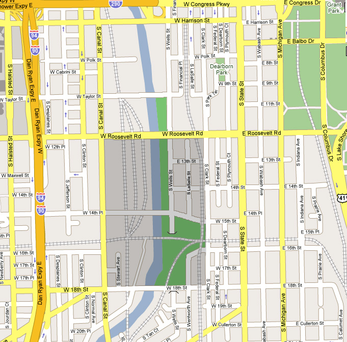
So, we have here a HUGE parcel in the South Loop, with no streets running through it. Difficulties come from the fact that there are several rail tracks running through it, and the community of Dearborn Park along the eastern edge, which for privacy concerns limits through streets.
The basic form of the grid-block portion will be medium-density residential, anywhere from 4 to 20 stories, with ground-level retail and parking planned for.
This is desirable because many blocks front onto the park, which allows them good views of the river and park. Also, for the relaxation and enjoyment of the residents, nearly half the total area of the property has been set aside for park usage. Wells Street will be buried at the south end of the park, so the park can be continuous and undisturbed.
The elimination of the St. Charles Air Line, which is the rail line that runs east out of this property, has been considered. If this happens, the two east-west rail tracks on the property will become unnecessary. They can then be removed, allowing a more connective park. They can also be replaced with bike trails, if desired.
15th Street has been extended across the river, and connected with 14th Place across the river. This is a good location for a new bridge because it is roughly halfway between the nearest bridges to the north and south at Roosevelt Road and 18th Street. Wells Street has been extended from its current end all the way through this property to connect with the other segment of Wells Street in Chinatown.
The name LaSalle Street has been chosen for the middle street in the grid portion because on a strictly east-west basis, it is very close to the northern portion of LaSalle. Also because the next closest street, Financial Place, does not sound very desirable as an address. However, this segment of LaSalle Street cannot continue north underneath Roosevelt without interfering with the Roosevelt Collection project immediately north of Roosevelt. Therefore it ends in a cul-de-sac just south of Roosevelt.
Lastly, the southeast corner of the parcel has several active rail uses. Therefore, Wentworth Street has been extended and linked with an extension of 16th Street, creating a block. In this block, a CTA Red Line station will be built. If Metra is amenable, this can become a transfer station between the two transit systems.> |

0 comments:
Post a Comment